By Nicholas Burnett, Director, Museum Conservation Services Ltd; Ken McNamara, Director, Sedgwick Museum, University of Cambridge; Sarah Finney, Conservator, Sedgwick Museum, University of Cambridge
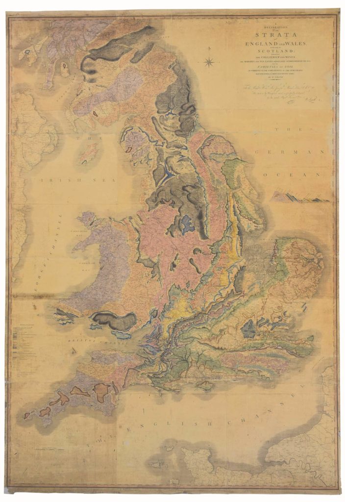
In the first instalment of Stripping the Land Bare, we described the recent conservation and restoration of William Smith’s 1815 geological map of England and Wales “A DELINEATION of the STRATA of ENGLAND and WALES with part of SCOTLAND; exhibiting the COLLIERIES and MINES; the MARSHES and FEN LANDS ORIGINALLY OVERFLOWED BY THE SEA; and the VARIETIES of Soil according to the Variations in the Sub Strata; ILLUSTRATED by the MOST DESCRIPTIVE NAMES”.
It could be claimed that this map, more than any other, had the greatest influence on the science of geology, for it inspired a generation of naturalists and fledgling geologists to establish geology as a coherent, robust and important science. The map was so large, that, for practicality’s sake, it was often sold in 15 separate sheets, either loose, or in a leather travelling case. A few, though, for the princely sum of £7, were “Mounted on Canvass [sic] and Rollers”, to be mounted on a wall. There were more than 400 subscribers willing to support this most ambitious endeavour, including Sir Joseph Banks, to whom the map is dedicated.
Once the direct conservation work on the map was complete, the other unique aspect of this project came to the fore: the framing and glazing. This was quite an unusual process and so is worth looking at in some detail.
In terms of ultimately displaying the map, the only way that this could be done was to find a product to glaze the map that would minimize the damaging effects of light (and visitors’ fingers). The glazing would need to be non-reflective, anti-static and block out UV light. Due to the map’s size, weight was an issue; glass would not have been suitable, especially as the area hallmarked for displaying the map was where children congregated. Tru Vue most generously offered in-kind support of the enormous sheet of Optium Museum Acrylic that would be required for the glazing.
The map is slightly larger than the maximum width of the Optium sheet. To get around this a frame moulding with a stepped rebate was created, the first step holding the Optium, the second step accommodating the map. We could have used a simpler L-shaped profile and compensated for the smaller glazing sheet by using blocks to hold it in place but this would have given a weaker frame. The dimensions of the moulding profile were carefully calculated as the space for hanging the map was very limited. The frame could only have 1 cm of clearance on each side.
In 1815 the blank paper margins at the top and bottom of the map had been left wider than the sides to give space for the attachment of the rollers. Fortunately the bottom margin bore Cary’s publisher’s details so we could show more of the margin there. Showing the excess width of the top margin would have looked strange. Rather than folding this margin around the stretcher, which would have been damaging for the paper, a second frame moulding was used for the top with an even wider rebate but an identical exterior to the first moulding.
Extra-long mouldings were cut to our specifications using ‘Tulip’ wood (American Poplar). This wood is hard enough to withstand the general public but not so hard as to make it impractical to cut in a foot operated Morso. However, the height of the profile meant the moulding had to be cut upside down in the Morso with the height stop removed otherwise it would simply not fit.
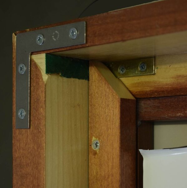
We were concerned that small children might use the bottom of the frame for climbing and so the frame corners were reinforced. After being glued and pinned the corners were strengthened with L-shaped metal plates, inset and screwed in place on the inside of the rebate and on the back of the frame. Long screws were also added through each corner. The wooden moulding was stained so as to fit in with the historic display cases in the Sedgwick Museum. The frame exterior was protected by a clear wax finish. The Optium was dust-sealed to the frame with a museum quality, clear, silicone sealant. Unlike most silicone sealants this does not release acetic acid as it cures, only water. Silicone sealant was chosen so that it would move with the Optium as it expanded and contracted according to temperature.
The 6 mm Optium is the thickest sheet available and so will deflect least when pressed against by members of the public. The distortion of acrylic can be compensated for by incorporating a thick spacer into the frame but we decided to increase its rigidity too by clamping it around all four edges. To do this we used spacers which were screwed to the frame while the Optium was supported so that it was not bowed.
All wooden surfaces within the frame interior were sealed with three coats of Dacrylate acrylic emulsion to help prevent off-gassing. Any holes made in the wood, such as for screws, were also sealed with copious quantities of Dacrylate. The wooden spacers and the screw heads were covered with 1650 micron thickness, ‘Heritage’, cream coloured, buffered acid-free board held in place with EVA adhesive.
The stretcher holding the map was positioned within the frame resting against the acid-free board. More pieces of ‘Heritage’ board were added in the gaps around the stretcher to hold the map in the correct position.
The map was going to hang on an external wall. We have treated a number of artworks damaged by mould as a result of hanging against external walls that subsequently became damp due to blocked gutters (and others due to condensation) so we wanted a good moisture barrier. A barrier layer of ‘Moistop’ (aluminium/polyester/polyethylene laminate film) was created by joining two strips of the film together with 3M, 425, aluminium tape and was placed behind the map. The same tape was used to hold the barrier film to the frame around all four sides so as to create an unbroken dust/insect seal.
Finally the frame was closed with a backboard cut from two pieces of 8 mm thickness, polycarbonate ‘Twinwall’ sheet. The join was positioned so it rested over one of the aluminium stretcher bars. The backboard was pinned in place and the pins covered with Filmoplast P90 self-adhesive tape.
William Smith, the creator of this astounding map, suffered many deprivations in his life. He became a bankrupt and ended up in debtor’s prison for a while. Perhaps, almost as galling, he was largely ignored by the geological establishment. However, he gained his due recognition from the Geological Society of London later in life when, in 1831, he was the first person to receive the society’s most prestigious award, the Wollaston Medal. Appropriately, given the hanging of his map in the Sedgwick Museum, it was Adam Sedgwick who presented Smith with the medal, bestowing on him the title of ‘Father of English Geology’. It is perhaps appropriate that the most recent recipient of the medal, awarded this year, is Professor James Jackson, the Head of Cambridge’s Department of Earth Sciences, in whose museum William Smith’s great map now hangs.
About The Author(s)
Ken McNamara
Director, Sedgwick Museum, University of Cambridge
Ken McNamara is a Senior Lecturer in the Department of Earth Sciences and Director of the Sedgwick Museum in the University of Cambridge. He has written over 20 books and 150 scientific articles on a range of geological and palaeontological topics, with a special focus on evolution and the fossil record. He is currently researching Dr John Woodward whose collection, given to the university in 1728, forms the basis for the Sedgwick Museum.

Nicholas Burnett
Director, Museum Conservation Services Ltd
Nicholas Burnett gained his conservation qualification at Camberwell School of Art and Crafts. He was subsequently one of the first conservators to be Accredited by the Institute of Paper Conservation. His professional career of 32 years started at the British Museum. This was followed by a spell running a conservation studio in the Fitzwilliam Museum. He is currently the director of Museum Conservation Services Ltd where he works for clients both in the UK and abroad. He specialises in works of art on paper and historic photographs.
Sarah Finney
Conservator, Sedgwick Museum, University of Cambridge
Sarah Finney is the Conservator at the Sedgwick Museum. She is involved in researching the origin & evolution of the earliest land vertebrates from the Devonian/ Carboniferous period. This involves fieldwork to collect fossils in The Arctic & Scottish Borders and working collaboratively with other museums in the UK and abroad. As Conservator at the Sedgwick Museum she cares for the Museum’s vast collection of fossils, minerals, rocks and an extensive archive. The Museum has a dedicated conservation laboratory based in West Cambridge.